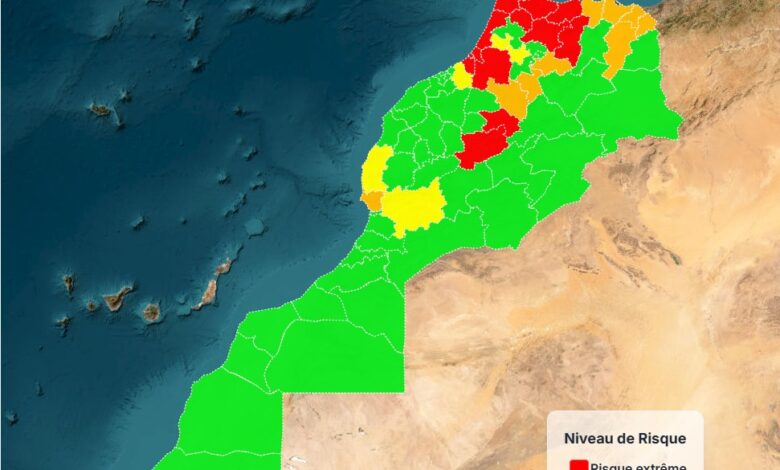
THE NATIONAL AGENCY FOR WATER AND FOREST PUBLISHES A NEW ACCURATE MAP OF FOREST FIRE RISK AREAS FOR THE DATES: FROM JUNE 27, 2025, TO JULY 24, 2025.

To anticipate the issue of forest fires in our country, the National Agency for Water and Forests (ANEF) produces precise maps that identify high-risk areas across the national territory through its scientific prediction models.
For the period from June 27, 2025, to July 4, 2025, and following an analysis of data including:
– The nature of forest formations and their levels of combustibility and flammability;
– Topographic and climatic conditions.
The following risk levels have been identified:
- Extreme Risk: In the provinces of Tanger-Assilah, Ouezzane, Larache, Chefchaouen, Taza, Taounate, Al Hoceima, Kénitra, Béni Mellal, Azilal, Skhirate-Témara, Salé, Rabat, and Khémisset.
- High Risk: In the provinces of M’Diq-Fnideq, Tétouan, Fahs-Anjra, Sefrou, Khénifra, Ifrane, Agadir-Ida-Ou-Tanane, Taourirt, Oujda-Angad, Nador, Berkane, and Driouch.
- Medium Risk: In the provinces of Sidi Slimane, Meknès, Essaouira, Benslimane, and Taroudannt.
The public is urged to remain vigilant, especially residents living near forests, summer visitors, and those working in forest areas, to take the necessary precautions to prevent forest fires.
Additionally, any observations of smoke or suspicious behavior should be reported promptly to local authorities.


