Risk of Wildfires: The National Agency for Water and Forests Issues a New Alert
Sure! Here’s the translation of the provided French article into fluent, high-quality English:
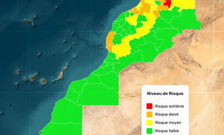
To address the issue of wildfires in our country, the ANEF produces precise risk maps using its scientific prediction models. These maps identify high-risk areas across the national territory.
For the period from August 1 to August 3, 2026, an analysis of data related to various factors—including forest types and their flammability, as well as topoclimatic parameters—reveals the following:
Extreme Risk: Found in the provinces of Al Hoceima, Chefchaouen, Fahs-Anjra, Larache, Tangier-Assilah, Tétouan, M’Diq-Fnideq, Nador, and Taza.
High Risk: Present in the provinces of Ouezzane, Berkane, Driouch, Ifrane, Sefrou, Taounate, Kénitra, Khémisset, Benslimane, Médiouna, Mohammedia, Nouaceur, Essaouira, and Agadir-Ida-Ou-Tanane.
- Moderate Risk: Identified in the provinces of Jerada, Oujda-Angad, Taourirt, Guercif, Meknès, El-Hajeb, Sidi Kacem, Sidi Slimane, Rabat, Salé, Skhirate-Témara, Azilal, Béni Mellal, Khénifra, Settat, Al-Haouz, and Taroudannt.
Residents living near forests and all summer visitors are urged to remain vigilant. This applies to individuals working in forested areas as well, who should take necessary precautions to prevent the outbreak of wildfires. In addition, it is vital to promptly alert local authorities upon noticing smoke or any suspicious behavior.
This translation maintains the article’s original meaning and tone while making it sound fluid and natural in English.